 NERC Data Catalogue Service
Mineral economics
Type of resources
Available actions
Topics
Keywords
Contact for the resource
Provided by
Years
Formats
Representation types
Update frequencies
Scale
-

This mineral resource data was produced as part of the Mineral Resource Map of Northern Ireland via a commission from the Northern Ireland Department of the Environment. The work resulted in a series of 21 data layers which were used to generate a series of six digitally generated maps. This work was completed in 2012 with one map for each of the six counties (including county boroughs) of Northern Ireland at a scale of 1:100 000. This data and the accompanying maps are intended to assist strategic decision making in respect of mineral extraction and the protection of important mineral resources against sterilisation. They bring together a wide range of information, much of which is scattered and not always available in a convenient form. The data has been produced by the collation and interpretation of mineral resource data principally held by the Geological Survey of Northern Ireland and was funded via a commission from the Northern Ireland Department of the Environment. These layers display the spatial data of the mineral resources of Northern Ireland. There are a series of layers which consist of: Bedrock: Clay, Coal & Lignite, Coal – lignite proven, Conglomerate, Dolomite, Igneous and meta-igneous rock, Limestone, a 100m buffer layer on the Ulster White Limestone, Meta-sedimentary rocks, Perlite, Salt, sandstone and Silica Sand. Superficial (unconsolidated recent sediments) : Sand & gravel and Peat. The data except for the salt and proven lignite resource layers was derived from the 1:50 00 and 1:250 000 scale DigMap NI dataset. A user guide 'The Mineral Resources of Northern Ireland digital dataset (version 1)' OR/12/039 describing the creation and use of the data is available. A companion set of data with the internal boundaries retained is also available.
-
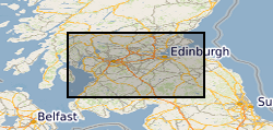
The British Geological Survey (BGS) was awarded a grant from the Scottish Government Aggregates Levy Fund in 2007 to provide a comprehensive, relevant and accessible information base to enhance the sustainability of mineral resources for 18 local authorities in the central belt of Scotland. BGS co-funded this project through its Sustainable Mineral Solutions project. This work was completed in March 2008. This dataset comprises the digital GIS files which were produced through this project. The major elements of minerals information presented are the geological distribution of all mineral resources in the Central Belt of Scotland. The BGS Mineral Resource data does not determine mineral reserves and therefore does not denote potential areas of extraction. Only onshore, mainland mineral resources are included in the dataset. This dataset has been produced by the collation and interpretation of mineral resource data principally held by the British Geological Survey. The mineral resource data presented are based on the best available information, but are not comprehensive and their quality is variable. The dataset should only be used to show a broad distribution of those mineral resources which may be of current or potential economic interest. The data should not be used to determine individual planning applications or in taking decisions on the acquisition or use of a particular piece of land, although they may give useful background information which sets a specific proposal in context.
-
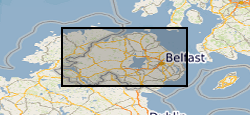
This mineral resource data was produced as part of the Mineral Resource Map of Northern Ireland via a commission from the Northern Ireland Department of the Environment. The work resulted in a series of 21 data layers which were used to generate a series of six digitally generated maps. This work was completed in 2012 with one map for each of the six counties (including county boroughs) of Northern Ireland at a scale of 1:100 000. This data and the accompanying maps are intended to assist strategic decision making in respect of mineral extraction and the protection of important mineral resources against sterilisation. They bring together a wide range of information, much of which is scattered and not always available in a convenient form. The data has been produced by the collation and interpretation of mineral resource data principally held by the Geological Survey of Northern Ireland and was funded via a commission from the Northern Ireland Department of the Environment. These layers display the spatial data of the mineral resources of Northern Ireland. There are a series of layers which consist of: Bedrock: Clay, Bauxitic clay, Coal & Lignite, Coal – lignite proven, Conglomerate, Dolomite, Igneous and meta-igneous rock, Limestone, a 100m buffer layer on the Ulster White Limestone, Meta-sedimentary rocks, Perlite, Salt, Sandstone and Silica Sand. Superficial (unconsolidated recent sediments) : Sand & gravel and Peat. The data except for the salt and proven lignite resource layers was derived from the 1:50 00 and 1:250 000 scale DigMap NI dataset. This version of the data retains the internal geological boundaries which are dissolved out in the accompanying dissolved version. A user guide 'The Mineral Resources of Northern Ireland digital dataset (version 1)' OR/12/039 describing the creation and use of the data is available.
-
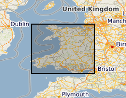
The British Geological Survey (BGS) was awarded a grant from the Welsh Assembly Government Aggregates Levy Fund in 2009 to provide a comprehensive, relevant and accessible information base to enhance the sustainability of mineral resources for Wales. BGS co-funded this project through its Sustainable Mineral Solutions project. This work was completed in 2010. This dataset comprises the digital GIS files which were produced through this project. The major elements of minerals information presented on the maps are; the geological distribution of all onshore mineral resources in Wales, the location of mineral extraction sites, the recorded occurrences of metallic minerals, the recorded location of former slate quarries and significant areas of slate waste and the recorded location of historic building stone quarries. The BGS Mineral Resource data does not determine mineral reserves and therefore does not denote potential areas of extraction. Only onshore, mainland mineral resources are included in the dataset. This dataset has been produced by the collation and interpretation of mineral resource data principally held by the British Geological Survey. The mineral resource data presented are based on the best available information, but are not comprehensive and their quality is variable. The dataset should only be used to show a broad distribution of those mineral resources which may be of current or potential economic interest. The data should not be used to determine individual planning applications or in taking decisions on the acquisition or use of a particular piece of land, although they may give useful background information which sets a specific proposal in context.
-
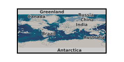
The British Geological Survey has one of the largest databases in the world on the production and trade of minerals. The dataset contains annual production statistics by mass for more than 70 mineral commodities covering the majority of economically important and internationally-traded minerals, metals and mineral-based materials. For each commodity the annual production statistics are recorded for individual countries, grouped by continent. Import and export statistics are also available for years up to 2002. Maintenance of the database is funded by the Science Budget and output is used by government, private industry and others in support of policy, economic analysis and commercial strategy. As far as possible the production data are compiled from primary, official sources. Quality assurance is maintained by participation in such groups as the International Consultative Group on Non-ferrous Metal Statistics. Individual commodity and country tables are available for sale on request.